
How Often Do Satellites Take Pictures of Earth?
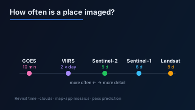
Quick Answer: It depends on the satellite. Geostationary weather satellites such as GOES and Himawari image a full disk every 10 minutes, and selected areas every 30 seconds to 2.5 minutes, at kilometre-scale detail. VIIRS covers the globe twice a day at 375–750 m, and MODIS every 1 to 2 days. The free 10–30 m missions are slower: Sentinel-2 revisits every 5 days at the Equator with two satellites, Landsat 8 and 9 together every 8 days, and Sentinel-1 radar repeats its orbit every 6 days with two satellites. Cloud covers about two thirds of Earth at any time, so usable optical images arrive less often than the satellites pass. Map apps show mosaics collected over time, not live images.
Satellites photograph Earth constantly, but no single satellite photographs every place constantly. How often a given spot is imaged depends on the orbit, the width of the strip the sensor sees, and how many satellites fly together. A geostationary weather satellite images half the planet every 10 minutes. A free 10 m optical mission such as Sentinel-2 comes back every 5 days at the Equator, and a cloudy day means that visit produced no usable picture.
This article gives the numbers for the main public missions, with the official source for each, and explains why the picture in a map app is usually older than any of them. The orbit mechanics behind the numbers are in Satellite Orbit Types: SSO, Polar & GEO Explained, and the trade-off between detail and frequency is in Spatial vs Temporal Resolution.
How often do satellites take pictures of the same place?
Anywhere from every 30 seconds to every couple of weeks, and the faster the revisit, the coarser the picture. Geostationary weather satellites rescan a full disk every 10 minutes at kilometre scale. Wide-swath polar orbiters such as VIIRS cover the whole globe twice a day at hundreds of metres. Free 10–30 m missions such as Sentinel-2 and Landsat return every 5 to 16 days, depending on how many satellites are flying.
The table gives the published figure for each mission, the revisit time it refers to, and the page that states it.
| Satellite | Sensor | How often a place is imaged | Source |
|---|---|---|---|
| GOES-East / GOES-West (ABI) | Geostationary, optical and infrared | Full disk every 10 minutes; US mainland every 5 minutes; one or two smaller areas every 30–60 seconds | NOAA NESDIS |
| Himawari (AHI) | Geostationary, optical and infrared | Full disk every 10 minutes; Japan area every 2.5 minutes | JMA |
| VIIRS | Polar orbit, optical and infrared, 375 m and 750 m | Complete coverage of the globe twice daily | NOAA VIIRS Imagery User's Guide |
| MODIS (Terra, Aqua) | Polar orbit, optical and infrared | Global coverage every 1 to 2 days | NASA Earthdata |
| Sentinel-2 | Optical, 10 m | 5 days at the Equator with two satellites; 10 days for one | SentiWiki |
| Landsat 8 and Landsat 9 | Optical, 30 m | 16-day repeat each, offset by 8 days; complete coverage every eight days together | USGS, USGS release |
| Sentinel-1 | C-band radar, 5 m × 20 m in IW mode | 12-day repeat per satellite; 6-day exact repeat with two | SentiWiki |
| NISAR | L-band radar | Land and ice every 12 days; on average every 6 days | NASA |
The figures are design values for each mission. Whether a picture you can use exists for a particular day also depends on what the mission acquired and, for the optical sensors, on cloud and daylight.
What is the difference between revisit time and repeat cycle?
The repeat cycle is how long a satellite takes to fly exactly the same ground track again. Revisit time is how often a given point falls inside some swath, which can be shorter because neighbouring swaths overlap. Sentinel-2 repeats its track every 10 days per satellite, and two satellites give a 5-day revisit at the Equator. Away from the Equator, revisit improves further.
The reason is geometry. Polar orbits converge towards the poles, so adjacent swaths overlap more at high latitudes. The USGS Landsat 9 page gives the overlap between neighbouring Landsat paths as about 7 percent at the Equator and about 85 percent at extreme latitudes. A place in northern Europe therefore sits inside more swaths per cycle than a place in Ecuador, and is imaged more often by the same satellites.
A wider swath has the same effect. VIIRS sees a strip about 3,060 km wide, which the NOAA user's guide says is wide enough to cover the globe "with no data gaps near the Equator". Sentinel-2's swath is 290 km and Sentinel-1's is 250 km, which is why they need days rather than hours to cover the same ground.
Which satellites image the whole Earth every day?
The wide-swath polar orbiters: VIIRS and MODIS. VIIRS provides complete coverage of the globe twice daily, once in the early afternoon and once in the early morning, at 375 m and 750 m. MODIS, on NASA's Terra and Aqua satellites, has global coverage every 1 to 2 days. Both are built for regional views of fires, smoke, snow and night lights, not for individual buildings.
Two changes are under way in 2026, and anyone building a daily time series should know about them:
- Suomi NPP. NOAA says delivery of all Suomi NPP data products, VIIRS included, ends at 13:00 UTC on November 2, 2026, and points users to NOAA-21 (primary) and NOAA-20 (secondary) instead (NOAA NESDIS notice; NASA Earthdata, which notes the date is subject to change). VIIRS itself continues on NOAA-20 and NOAA-21.
- MODIS. NASA Earthdata states that the Terra and Aqua platforms will begin shutting down operations in late 2026 or early 2027, after which MODIS data will no longer be collected, and encourages users to move to similar VIIRS products (NASA Earthdata).
For what MODIS products contain and how they relate to VIIRS, see the MODIS satellite data guide. Night-time VIIRS imagery is covered in VIIRS nighttime lights time series monitoring.
How often do weather satellites take pictures?
Every few minutes. Geostationary weather satellites orbit at the speed of Earth's rotation, so each one stares at the same hemisphere permanently and rescans it on a fixed timeline. NOAA's GOES imager produces a full disk image every 10 minutes, the US mainland every five minutes, and one or two smaller areas every 30 to 60 seconds. Japan's Himawari imager scans the full disk every 10 minutes.
The price of that frequency is distance. A geostationary satellite sits about 35,786 km above the Equator, roughly fifty times higher than Landsat, so the detail is coarse. The JMA description of the Himawari imager gives a full-disk resolution at the sub-satellite point of 0.5 km in the visible band and 1 to 2 km in the others, and it scans the Japan area every 2.5 minutes. These satellites show weather systems, smoke plumes and large fires as they move. They cannot show a road or a ship, and the view becomes increasingly oblique towards the poles.
How often do Sentinel-2, Sentinel-1 and Landsat image a place?
Every few days, at 10 to 30 m. Sentinel-2 is designed for a 5-day revisit at the Equator with two satellites. Landsat 8 and Landsat 9 each repeat every 16 days, offset by 8 days, which gives complete coverage every eight days together. Sentinel-1 radar repeats its orbit every 12 days per satellite and every 6 days with two. All of them are free to download.
The current fleet matters, because these figures assume a full constellation:
- Sentinel-2. SentiWiki states that "Sentinel-2C has replaced Sentinel-2A in operation on January 21st, 2025", so the nominal pair is now Sentinel-2B and Sentinel-2C. Since March 2025, Sentinel-2A has been flying an extension campaign.
- Sentinel-1. ESA confirmed that "Sentinel-1A's operational duties ended on 29 June 2026". Sentinel-1C and Sentinel-1D now work in tandem, orbiting 180° apart, and SentiWiki gives a two-satellite constellation a 6-day exact repeat cycle. Sentinel-1 does not acquire every place on every pass: SentiWiki describes a pre-defined observation plan with set modes for land, coasts, seas and open ocean.
- Landsat. A USGS briefing from March 2026 lists both Landsat 8 and Landsat 9 in nominal operations, each collecting about 750 new scenes per day. The USGS states that Landsat 9 data are available for download at no charge, and Copernicus states that Sentinel data products are made available free of charge to all data users.
Combining the optical missions shortens the wait for a clear look. NASA's Harmonized Landsat and Sentinel-2 product is built for exactly that, and Sentinel-2 vs Landsat 9 compares the two sensors.
Do commercial satellites take pictures every day?
Some do, for a fee. Planet's PlanetScope fleet of small satellites, which images at 3 m, according to Planet's documentation, "captures imagery of nearly all of Earth's landmasses daily", with only imagery that meets its quality thresholds published. Very-high-resolution satellites work differently: they point off-nadir on request, so a picture of a specific place exists only if someone ordered it.
That distinction is easy to miss. A large commercial constellation can have many opportunities over a place each day, but an opportunity is not an image. Sub-metre optical and radar satellites mostly collect to order, so the archive for a particular place grows only where someone has asked for it. Free vs commercial satellite imagery compares what each option gives, and When Can a Satellite Next Image This Place? explains the difference between systematic collection and tasking.
How do clouds change how often you get a usable picture?
Clouds reduce the useful revisit of every optical satellite, and in cloudy regions the reduction is large. NASA's analysis of MODIS data from 2002 to 2015 found that about 67 percent of Earth's surface is typically covered by clouds. A Sentinel-2 pass every 5 days over a persistently cloudy region can still leave long gaps between clear views. Optical sensors also need daylight, so a night pass produces nothing.
Radar does not have this problem. Sentinel-1 and NISAR carry their own illumination at microwave wavelengths that pass through cloud, so for them the number of passes and the number of usable images are close to the same. Why SAR can see through clouds explains the physics, and Sentinel-2 cloud masking covers how cloudy pixels are flagged when you work with optical data.
The cloud fraction is a global figure. It varies strongly by place and season, so the practical way to judge a location is to look at its own recent acquisitions and count how many were clear over the spot you care about.
How often does Google update its satellite pictures?
Google does not publish a fixed update interval on its Google Earth help page. What it does say is that "images aren't in real time, so you won't see live changes" and that images are collected over time from providers and platforms. A mosaic taken over days or months is shown with a date range rather than one acquisition date.
So the imagery in Google Maps or Google Earth is a patchwork, chosen to be clear and seamless, and different parts of the same view can come from different dates. It is a good reference for what a place looks like, and a poor guide to what happened there last week. The same help page explains that the historical imagery time slider shows images "captured on or before that date", and that the time zone can be switched to UTC.
If you need the newest picture rather than the prettiest one, go to the archives of the systematic missions, which record the sensing time of every scene. How to find the most recent satellite image of any place walks through where to look. Off-Nadir Delta's Sentinel-2 viewer shows recent Sentinel-2 passes in natural colour on a live map without a login.
How do satellites take pictures in the first place?
Most Earth observation satellites do not take snapshots. An optical sensor such as the one on Sentinel-2 records a continuous strip under the satellite, line by line, as it moves along its orbit, and the strip is later cut into scenes. Radar satellites such as Sentinel-1 send microwave pulses sideways and build the image from the echoes.
That is why revisit is described in terms of swaths and tracks rather than photographs: a place is "imaged" when it falls inside the strip a sensor records on some pass. How do satellites actually capture images? covers pushbroom, whiskbroom and SAR imaging in detail.
How can you tell when a satellite will next pass over a place?
Work it out from the orbit. The free systematic satellites fly fixed, repeating orbits whose elements are public, so the next time a place falls inside a given swath can be predicted days ahead. The prediction gives an opportunity, not a guarantee: whether a scene is actually acquired depends on the mission's plan, and for optical sensors on cloud and daylight.
Off-Nadir Delta's satellite pass prediction computes the next access windows over a point (or the centre of an area) for Sentinel-1, Sentinel-2, Landsat 8/9 and NISAR, and for several commercial tasking platforms, over a window of up to seven days. Each window says which satellite passes, when, and whether the pass is ascending or descending. The same prediction is available to Delta Agent and over the API, so an assistant can answer "when can this place next be imaged?" before you decide whether to wait for a free image or pay for tasking.
If the answer is a regular watch on the place rather than one picture, satellite area monitoring lets you draw the area once and track how it changes over time in satellite imagery.

Remote sensing specialist with 10+ years in satellite data processing and AI. Founder of Off-Nadir Lab. Ph.D. in Informatics (Yokohama National University, 2026). Master's in Earth System Science and Technology (Kyushu University). Co-author, Remote Sensing Encyclopedia. More about the author →