
When Can a Satellite Next Image This Place? Pass Prediction, Explained
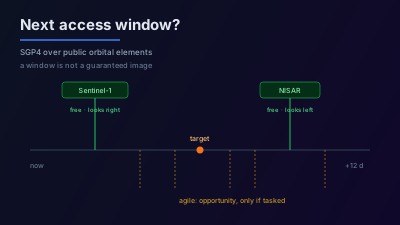
Quick Answer: Satellite pass prediction propagates public orbital elements with SGP4 and tests whether a target falls inside a satellite's imaging geometry. Systematic collectors — Sentinel-1, Sentinel-2, NISAR, Landsat — fly fixed repeat cycles (12 days for Sentinel-1 and NISAR) and image for free when their swath covers you, so a predicted window is a reliable expectation. Agile commercial platforms slew off-nadir on command, so they show many more windows, but each is an access opportunity that only becomes an image if someone pays to task it. Geometry decides the rest: Sentinel-1 looks right, NISAR looks left, and in terrain that changes what a pass can measure.
"When can we get a picture of this?" is the first question after almost any event, and it has a worse answer than most people expect. Not because the orbits are unknown — they are published — but because a satellite being overhead and a usable image existing are two different things.
This post covers how access windows are actually computed, the distinction that decides whether a predicted window means anything, and how to read the geometry that comes with it.
How is a satellite pass predicted?
Pass prediction propagates each satellite's orbit forward in time and tests whether a target falls inside that platform's imaging geometry. The orbital data are general perturbations element sets — TLEs — produced by fitting US Space Surveillance Network observations, distributed publicly by CelesTrak with no account required, and intended for use with the SGP4 propagator. Position comes from the propagator; whether that position can see your target comes from the sensor.
The access test differs by platform type, and this is where most confusion starts. A systematic collector images along a fixed swath, so the test is geometric containment: is the target inside the swath as the ground track goes by? An agile platform can point off-nadir, so the test is whether the target falls inside the cone the spacecraft can slew to — a much larger area, producing many more candidate windows.
What is the difference between systematic and agile collection?
Systematic collectors fly a repeating orbit and image near-nadir on a published schedule, and their data is free and open. You cannot ask them to look at your area — you can only work out when they will pass. Agile commercial platforms steer off-nadir on command, so they have opportunities over almost anywhere daily, but each opportunity requires a paid tasking order before anything is collected.
That difference changes what a predicted window means:
| Systematic | Agile commercial | |
|---|---|---|
| Examples | Sentinel-1, Sentinel-2, NISAR, Landsat-8/9 | WorldView, ICEYE, Capella, SkySat |
| Pointing | Near-nadir, fixed swath | Steerable off-nadir |
| Windows over a place | Few, on a repeat cycle | Many, most days |
| Cost | Free and open data | Commercial tasking order |
| A predicted window means | It is expected to image | It could image, if ordered |
The practical consequence: a long list of upcoming windows over your area is not good news if they are all agile platforms. It means many opportunities to spend money, not many images on the way.
Does an access window guarantee an image will exist?
No. Geometric access establishes that a place can be imaged at a given time. Whether a scene reaches a catalogue depends on the mission's acquisition plan, on downlink and processing capacity, and — for commercial platforms — on whether anyone ordered the collect. Treating predicted windows as scheduled imagery is the most common way collection planning goes wrong.
For the systematic missions there is a better guide: the exact repeat cycle. Sentinel-1 flies a 12-day repeat cycle with 175 orbits per cycle for a single satellite, per ESA's mission documentation. NISAR has a 12-day exact repeat cycle at 747 km altitude. Those cycles tell you when the archive should gain something, which is the question you actually had.
Why does cloud change the answer?
Optical sensors need daylight and a clear line of sight, so a Sentinel-2 or Landsat pass over cloud produces no usable scene and a night pass produces nothing at all. Synthetic-aperture radar supplies its own illumination and passes through cloud, so a Sentinel-1 or NISAR window is usable whatever the weather. For most urgent questions, the earliest real answer is a SAR pass, not the optical one that looks better.
This is why "next pass" and "next usable image" diverge so sharply in some places and barely at all in others. Over a persistently cloudy tropical coast in the wet season, an optical revisit figure is close to meaningless — the sensor will be overhead on schedule and see nothing. The difference between SAR and optical is not a preference; for a cloudy target it decides whether waiting is viable.
Which geometry does a window come with, and why does it matter?
A window carries more than a timestamp: the orbit direction and, for radar, the look side and incidence angle. Sentinel-1's Interferometric Wide mode covers a 250 km swath at incidence angles from 29.1° to 46.0°, and its antenna illuminates the ground to the right of the flight path. NISAR looks left, at L-band with a 24 cm wavelength.
In flat terrain this is bookkeeping. In relief it decides the answer. Look direction and incidence together determine which slopes are foreshortened, which are laid over on top of each other, and which fall into radar shadow — a valley wall facing away from the antenna can be unmeasurable on one pass and clean on the next, purely from geometry. Two Sentinel-1 windows over the same mountain site three days apart, one ascending and one descending, are not interchangeable. The related question of ascending versus descending orbits is the same issue seen from the other side.
Because Sentinel-1 looks right and NISAR looks left, the two missions illuminate opposite flanks of the same terrain. That is an advantage when a slope is shadowed for one of them, and a trap if you assume an L-band window substitutes for a C-band one over steep ground.
How do you decide between waiting and tasking?
Turn it into arithmetic rather than instinct. Establish the deadline, then find the earliest systematic window that can actually see the target — SAR if cloud is likely, optical if you need interpretability and the sky is expected to be clear. If that window lands inside the deadline, waiting costs nothing. If it does not, you now know the exact size of the gap, which is the only honest basis for deciding whether a commercial tasking order is worth its price.
The gap is often smaller than assumed. With Sentinel-1 and NISAR both on 12-day repeat cycles and different look directions, and Sentinel-2 revisiting far more often than either, a mid-latitude target frequently has a usable free window within a few days. Paying to task before checking is how collection budgets are spent on images that were going to arrive anyway.
Where this fits
Pass prediction is the front half of collection planning: it tells you what is possible and when. It does not tell you whether the resulting scene will show what you need — that depends on resolution, on terrain geometry, and on what the event actually looks like from orbit. For the terminology used here, the glossary defines incidence angle, swath, revisit, and layover. For the standing question of keeping an area under observation rather than checking it once, see satellite area monitoring, and for the access-window computation itself, satellite pass prediction.
Orbital element sets describe where satellites are, not what anyone is collecting. Predicted windows for commercial platforms are access opportunities computed from public data — they are not knowledge of, or a claim about, any operator's tasking activity.

Remote sensing specialist with 10+ years in satellite data processing and AI. Founder of Off-Nadir Lab. Ph.D. in Informatics (Yokohama National University, 2026). Master's in Earth System Science and Technology (Kyushu University). Co-author, Remote Sensing Encyclopedia. More about the author →