
NISAR L-Band SAR vs Sentinel-1 C-Band: When Does Wavelength Decide the Answer?
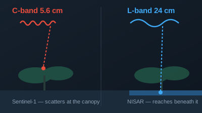
Quick Answer: NISAR carries an L-band radar with a 24 cm wavelength; Sentinel-1 carries C-band at 5.55 cm. The longer wave penetrates deeper into vegetation, so NISAR sees flooding beneath tall canopy and structure inside forests that C-band only skims the top of, and it keeps interferometric coherence over vegetated terrain where C-band decorrelates in days. C-band is not obsolete: Sentinel-1 has an archive back to 2014 and reaches a repeat pair twice as fast, and it remains the better first look for open-water flooding, urban change, and anything needing history. NISAR's public GCOV products are distributed free by the Alaska Satellite Facility, but the collections released so far are labelled beta and provisional, so treat their backscatter values as indicative rather than measured.
Wavelength is the one radar parameter you cannot compensate for in processing. NISAR's L-band radar operates at a 24 cm wavelength and Sentinel-1's C-band at 5.405 GHz, about 5.55 cm, and that ratio of roughly four decides how deep the signal reaches into a forest canopy before it scatters back. Everything else in this comparison — flood mapping under trees, biomass sensitivity, how long interferometric coherence survives — follows from that one number.
What is NISAR and what does it actually carry?
NISAR is a joint NASA–ISRO radar satellite launched on 30 July 2025 from the Satish Dhawan Space Centre in India. It flies at 747 km in a 98.4° sun-synchronous orbit and carries two radars: an L-band instrument at 24 cm wavelength built by NASA, and an S-band instrument at 9.4 cm wavelength built by ISRO. According to NASA's mission overview, the satellite "observes Earth every 12 days from both ascending and descending orbits, providing an average revisit time of about 6 days," with SAR resolution of 3–10 metres depending on acquisition mode and a three-year baseline mission.
Those two numbers are easy to confuse and they answer different questions. The 12-day repeat is what governs whether you can form a change pair from the same viewing geometry. The ~6-day average revisit is what governs how soon any look becomes available after an event, because ascending and descending passes see the same ground from opposite sides.
How does a 24 cm wavelength change what the radar sees?
Radar interacts most strongly with objects comparable in size to its wavelength. C-band's 5.55 cm wave scatters off leaves and small twigs, so a C-band image of a forest is largely an image of the canopy surface. L-band's 24 cm wave passes through that leaf layer and interacts with branches, trunks, and the ground beneath.
This produces three practical consequences:
| Question | C-band (Sentinel-1, 5.55 cm) | L-band (NISAR, 24 cm) |
|---|---|---|
| Flooding under tall canopy | Largely blind — the canopy dominates the return | Detects the double-bounce between water surface and trunks |
| Forest structure and biomass | Saturates at low biomass; senses canopy | Sensitive to woody structure, saturates later |
| InSAR coherence over vegetation | Decorrelates quickly over vegetated terrain | Retains coherence far longer |
| Open water, urban change, bare ground | Fully capable | Also capable, with no particular advantage |
| Archive depth | Back to 2014 (Sentinel-1A launched 3 April 2014) | Begins 16 June 2026 |
| Repeat cycle | 12 days per satellite, ~6 days with the constellation | 12 days; ~6-day average revisit combining ascending and descending |
The flooded-forest case is the clearest example of a question where the sensor choice, not the analysis, determines whether the answer exists at all. Under a closed canopy, water on the ground and dry ground can look nearly identical to C-band because neither signal reaches the surface. At L-band, standing water beneath trees produces a strong double-bounce return — the wave reflects off the smooth water surface, then off the trunk, and back to the sensor — which reads as a distinctive brightening.
What is a GCOV product and how do you use it?
GCOV is NISAR's geocoded, analysis-ready backscatter product. NASA Earthdata describes it as being "Derived from the Level-1 RSLC product," providing "calibrated backscatter measurements in gamma-0 power values, corrected for both radiometric and terrain distortions." Crucially for anyone with an existing SAR workflow, the same page notes that GCOV "can be used in the same way as Normalized Radar Backscatter (NRB) or Radiometrically Terrain Corrected (RTC) products."
In other words, if you already process Sentinel-1 RTC, GCOV drops into the same slot. It is terrain-corrected gamma-0 on a map grid, not raw slant-range data.
A published GCOV granule carries two grids covering the same footprint. Reading the metadata of one L-band granule over the Kantō region of Japan shows a frequency-A grid of 35,064 × 35,568 pixels at 10 m spacing, and a frequency-B grid of 4,383 × 4,446 pixels at 80 m spacing — the same ground area at one-eighth the sampling. The file records its centre frequencies as 1,239.0 MHz for frequency A and 1,293.5 MHz for frequency B, which correspond to wavelengths of 24.2 cm and 23.2 cm. The whole granule is about 6.4 GiB of HDF5.
That 80 m grid is genuinely useful and often overlooked: it is the product's own overview, so a whole-scene view does not require decimating the 10 m grid.
Which polarizations does NISAR provide, and why not VV and VH?
Published NISAR GCOV granules in the dual-pol horizontal mode carry HH and HV — horizontal transmit, horizontal receive, and horizontal transmit, vertical receive. Sentinel-1's land-mode default is VV and VH, vertical transmit.
Do not carry Sentinel-1 polarization intuitions across unchanged. Transmit polarization affects how the wave interacts with vertically oriented structure such as tree trunks and stems, so HH and VV are not interchangeable measurements of the same thing. The cross-polarized channel — HV for NISAR, VH for Sentinel-1 — is in both cases the one sensitive to volume scattering from randomly oriented scatterers, which is why cross-pol is the usual starting point for vegetation and debris.
Is NISAR data calibrated yet?
Not fully, and this matters if you intend to report absolute backscatter values.
NASA Earthdata records that "In February 2026, the NISAR mission team released more than 100,000 pre-calibration Level 1 to Level 3 L-band data products," and that "The full global release of calibrated NISAR data products is scheduled for July 2026." As of 3 August 2026, a search of the NASA Common Metadata Repository for ASF-hosted NISAR GCOV collections returns two maturity levels — a beta collection and a provisional collection — and no separately published calibrated collection.
The practical reading:
- Relative comparisons within a scene, and change between two scenes of the same collection, are the defensible uses today.
- Absolute gamma-0 values quoted as measurements are not, until calibrated products are published.
- Provisional data carries the maturity label in the collection name itself, which is a deliberate signal from the data provider rather than a technicality to skip past.
Off-Nadir Delta labels NISAR layers as provisionally calibrated for exactly this reason.
When should you choose Sentinel-1 over NISAR?
Choose Sentinel-1 when any of these apply, which is more often than the wavelength discussion suggests:
- You need history. Sentinel-1 has acquired since 2014. NISAR's earliest public GCOV acquisition is 16 June 2026, so no NISAR pair can describe a change that happened before then.
- The target is open water, bare ground, or urban. The canopy-penetration advantage does not apply, and Sentinel-1's deeper archive wins.
- You need a same-geometry change pair quickly. Sentinel-1 reaches a 6-day repeat with the constellation; NISAR's repeat is 12 days, so an interferometric or same-orbit pair comes twice as fast from Sentinel-1. For any post-event look the two are comparable, because NISAR's ascending and descending passes average about 6 days.
Choose NISAR when the question is specifically about what is underneath vegetation, or about woody structure. (L-band also holds interferometric coherence far better over vegetation, but that needs the interferometric products, not the GCOV backscatter product described here.) For a flood in a forested basin, L-band is not an incremental improvement — it is the difference between an answer and a blank.
A practical pattern is to run both: C-band for the fast, well-archived screening look, and L-band where the canopy is the obstacle. Neither replaces the other.
Where does NISAR data come from, and what does it cost?
NASA states the NISAR data policy is "Free & open," with L-band data distributed through the Alaska Satellite Facility (ASF), and S-band and L-band over India and select global sites through ISRO's Bhoonidhi portal. There is no licence fee for the imagery itself. The costs that remain are the practical ones: a single granule is several gigabytes of HDF5, so working with it means either bulk download and local processing, or a service that reads and converts the area you care about.
Off-Nadir Delta takes the second approach — you draw an area, and only that area is converted for display. NISAR access is included on paid plans; see the pricing page for current plan details.
Related reading
- VV, VH, HH, HV: SAR Polarization Demystified — what each polarization channel actually measures
- Why SAR Sees Through Clouds — the physics behind all-weather radar imaging
- Flood Mapping with SAR: A Practical Workflow — turning backscatter into water extent
- Data Sources — every imagery source behind Off-Nadir Delta, with licences and citations
- Glossary — definitions for backscatter, coherence, gamma-0, and related terms

Remote sensing specialist with 10+ years in satellite data processing and AI. Founder of Off-Nadir Lab. Master's in Earth System Science and Technology (Kyushu University). Co-author, Remote Sensing Encyclopedia. More about the author →