SAR Imaging Modes: Stripmap, ScanSAR, TOPS, Spotlight
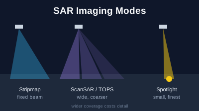
Quick Answer: A SAR imaging mode is the way the radar points its beam during a pass, and it sets the trade between how wide an area is imaged and how fine the detail is. Stripmap keeps the beam fixed and images a continuous strip (Sentinel-1 SM: 80 km at about 5 m × 5 m). ScanSAR and its variant TOPS switch the beam between sub-swaths to cover a wide area at coarser resolution (Sentinel-1 IW: 250 km at 5 m × 20 m; EW: about 400 km at 20 m × 40 m). Spotlight steers the beam to stay on one spot for longer, giving sub-metre detail over a few kilometres (TerraSAR-X Staring SpotLight: 0.25 m over 4 × 3.7 km). Dwell is ICEYE's name for a very long spotlight.
A SAR imaging mode is how a radar satellite points its beam while it flies past, and it decides two things at once: how wide a strip of ground is imaged and how much detail the image has. Wider coverage costs detail. Stripmap images a continuous strip at medium resolution, ScanSAR and TOPS cover a wide swath at coarser resolution, and spotlight concentrates on one small area at the finest resolution. Free systematic missions such as Sentinel-1 mostly use the wide modes; commercial satellites sell spotlight.
The modes exist because a synthetic aperture radar builds its fine detail along the flight direction from how long it keeps a target in view. Keep it in view longer and the detail gets finer; sweep the beam across several sub-swaths and each target is seen for less time. Every mode below is a different answer to that trade. For the basics of how SAR forms an image, start with the SAR complete guide.
What are the main SAR imaging modes?
There are three basic modes, plus variants that operators name differently. Stripmap points the beam in a fixed direction. ScanSAR switches the beam between several sub-swaths to widen coverage, and TOPS is a ScanSAR variant that also sweeps the beam along the flight direction. Spotlight steers the beam to keep illuminating one area. The table shows how they trade coverage for detail on four satellites.
| Mode | How the beam moves | Coverage | Detail | Example (source) |
|---|---|---|---|---|
| Stripmap | Fixed pointing | Medium strip | Medium | Sentinel-1 SM: 80 km, about 5 m × 5 m (SentiWiki); TerraSAR-X SM: 3 m, 30 × 50 km scene (ESA) |
| ScanSAR | Switches between sub-swaths across the track | Wide | Coarse | TerraSAR-X ScanSAR: 18 m, 100 × 150 km; Wide ScanSAR: 40 m, 270 × 200 km (ESA) |
| TOPS (TOPSAR) | ScanSAR plus a sweep along the track in each burst | Wide | Coarse, more even | Sentinel-1 IW: 250 km, 5 m × 20 m; EW: about 400 km, 20 m × 40 m (SentiWiki) |
| Spotlight | Steered to stay on one area | Small scene | Fine | TerraSAR-X Staring SpotLight: 0.25 m, 4 × 3.7 km (ESA); ICEYE Spot: 1 m, 5 × 5 km (ICEYE) |
Resolutions are single-look values as published, given as range × azimuth where the operator gives two numbers. Products delivered to users are often multi-looked to reduce speckle and resampled, so a product's pixel spacing is not the same as the resolution in this table.
What is stripmap mode?
Stripmap is the simplest SAR mode: the antenna points in one fixed direction to the side of the satellite, and the image is a continuous strip along the ground track. Each point on the ground is in the beam for the full time the beam sweeps past it, which gives a good balance of detail and coverage. Sentinel-1's Stripmap mode images an 80 km swath "at slightly better than 5 m by 5 m spatial resolution (single look)" (ESA SentiWiki).
Stripmap is the mode to use when a medium-sized area needs consistent detail along a long track, such as a coastline or a river. TerraSAR-X's stripmap scene is 30 × 50 km at 3 m and can be extended along track up to 30 × 1,650 km (ESA); ICEYE's Strip mode is 3 m over 30 × 50 km (ICEYE). Sentinel-1 does not use Stripmap routinely: ESA states that "SM mode is only used for small islands and on request for extraordinary events such as emergency management" (ESA SentiWiki).
What is ScanSAR mode?
ScanSAR widens the swath by switching the beam between several sub-swaths at different angles across the track. Because the beam spends only part of its time on each sub-swath, every point on the ground is illuminated for a shorter time than in stripmap, and the detail along the flight direction gets coarser. The University of Twente's ITC course material states that this "leads to a degradation of the azimuth resolution", while ScanSAR "allow[s] a larger coverage in range direction than the other imaging modes" (ITC, University of Twente).
ScanSAR is the mode for mapping large areas regularly: sea ice, large floods, oil slicks at sea, regional soil moisture. JAXA's ALOS-2 PALSAR-2 ScanSAR covers a 350 km swath with 5 scans and a 490 km swath with 7 scans (JAXA); TerraSAR-X's Wide ScanSAR covers 270 × 200 km at 40 m (ESA). Classic ScanSAR has a known artefact, scalloping: periodic brightness stripes along the track, caused by each target being seen through a different part of the beam.
What is TOPS, and why does Sentinel-1 use it?
TOPS, or TOPSAR (Terrain Observation with Progressive Scans), is a form of ScanSAR that also sweeps the beam along the flight direction during each burst. ESA describes it as "a form of ScanSAR imaging, where data is acquired in bursts" (SentiWiki: Sentinel-1 processing), in which "the beam is also electronically steered from backward to forward in the azimuth direction for each burst", and states that "the TOPSAR technique greatly reduces scalloping effects over conventional ScanSAR" (SentiWiki: Sentinel-1 mission). The technique was described by De Zan and Monti Guarnieri in IEEE Transactions on Geoscience and Remote Sensing in 2006 (doi:10.1109/TGRS.2006.873853).
Sentinel-1's two wide modes are TOPS modes. Interferometric Wide swath (IW) acquires a 250 km swath in three sub-swaths at 5 m × 20 m; Extra Wide swath (EW) acquires about 400 km at 20 m × 40 m. ESA's mission page gives 400 km in its text and 410 km in a table, so expect either figure in other sources (SentiWiki). The even image quality across the swath is what makes IW suitable for InSAR: ESA designed the system to synchronise bursts between repeat passes, so images of the same place from different dates line up burst by burst.
What is spotlight mode, and what is dwell?
Spotlight steers the beam backwards as the satellite flies past, so it keeps illuminating the same area for longer than the beam would naturally stay on it. A longer look gives finer detail along the flight direction but limits the image to a small scene. ITC describes spotlight as "increasing the illumination time of a particular area of interest by steering the antenna beam in azimuth direction", with an azimuth resolution "highly enhanced" at the cost of coverage (ITC, University of Twente).
Spotlight is the mode commercial SAR operators sell for detailed work on one site, such as a port, an airfield or a damaged building. TerraSAR-X offers SpotLight at 2 m over 10 × 10 km, High Resolution SpotLight at 1 m over 10 × 5 km and Staring SpotLight at 0.25 m over 4 × 3.7 km (ESA). Umbra advertises spotlight resolutions of 25 cm to 1 m and scene sizes between 5 × 5 km and 10 × 10 km (Umbra). Capella lists azimuth resolutions of 0.25 m for Spotlight Ultra and 0.5 m for Spotlight, with dwell times of 28–52 s and 8–16 s respectively (Capella Space).
Dwell is ICEYE's name for a spotlight collection with a "very long illumination period to achieve a very fine azimuth resolution and highly reduced speckle because of multi-looking" (ICEYE product specification). ICEYE lists Dwell at 1 m, Dwell Fine at 0.5 m and Dwell Precise at 0.25 m, all over 5 × 5 km. The long look is used either for finer detail or, at the same detail, for a cleaner image with less speckle (SAR speckle explained).
Which mode does Sentinel-1 use, and why does it matter for the archive?
Sentinel-1 uses Interferometric Wide swath mode over land and Wave mode over the open ocean. ESA states that "the primary mode over land is IW, with VV+VH polarisation" and that over open ocean "the WV mode, with VV polarisation, is the main operational acquisition mode" (ESA SentiWiki). Wave mode records small 20 × 20 km vignettes at 5 m × 5 m every 100 km along the orbit, for measuring ocean waves; it is not a continuous image. Extra Wide swath "is aimed primarily for use over sea-ice, polar zones and certain maritime areas" (same source).
The mode matters because Sentinel-1 does not change it to suit a request. ESA uses the same polarisation scheme over a given area systematically "to produce a consistent long-term data archive built for applications based on long time series" (ESA SentiWiki). The practical result is that almost every free Sentinel-1 image of a place on land is an IW image at about 5 m × 20 m, available since 2014, and that the archive suits time-series change monitoring and InSAR. If you need 1 m radar detail of a site, no free systematic archive has it; it has to be tasked from a commercial operator.
Sentinel-1A ended its operational duties on 29 June 2026, and Sentinel-1C and Sentinel-1D now fly in tandem (ESA). The modes are the same on all Sentinel-1 satellites.
How does NISAR's SweepSAR mode differ?
NISAR uses SweepSAR, a technique NASA describes as "scan-on-receive wide swath mapping", to image a swath of about 240 km (NASA: NISAR satellite). Instead of switching its transmit beam between sub-swaths as ScanSAR does, the radar transmits one beam that illuminates "the full 242-km swath" and sweeps its receiving feed across the antenna reflector to collect the echoes; NASA says this gives "wide area coverage and fine spatial resolution at the same time" (NASA: SweepSAR). NASA gives 7 m resolution along track and 2–8 m across track for the L-band radar, and states that resolution depends on the acquisition mode (NASA: NISAR mission overview).
NISAR carries a 24 cm L-band radar and a 9.4 cm S-band radar. Its L-band data are distributed by the Alaska Satellite Facility, and the S-band radar is used mainly over India (ASF NISAR docs). How L-band compares with Sentinel-1's 5.5 cm C-band is covered in NISAR L-Band SAR vs Sentinel-1 C-Band.
How do you choose a SAR imaging mode?
Choose by the smallest thing you need to see and the area you need to cover, then check what exists before ordering anything. For a region, a flood or a country, the wide free modes are the answer: Sentinel-1 IW covers 250 km per pass and has an archive back to 2014. For a single site where objects are a few metres across, only a commercial stripmap or spotlight image resolves them, and it has to be ordered for a date.
| Need | Mode to look for | Where it comes from |
|---|---|---|
| Change over a region, flood extent, regular monitoring | ScanSAR or TOPS (Sentinel-1 IW, EW) | Free systematic archive |
| Ground deformation (InSAR) | TOPS IW, or stripmap from a mission with a matching repeat archive | Free systematic archive (Sentinel-1), NISAR |
| A coastline, a river or a corridor at a few metres | Stripmap | Commercial or on-request |
| A port, an airfield, a damaged building at sub-metre detail | Spotlight or dwell | Commercial tasking |
The other trade is time. A wide mode revisits the same place on a fixed cycle; a spotlight image exists only if someone ordered it. When Can a Satellite Next Image This Place? explains the difference between systematic and tasked collection, and SAR vs Optical Satellite Imagery explains when radar is the right sensor in the first place.
Which SAR modes can you use in Off-Nadir Delta?
Off-Nadir Delta serves Sentinel-1 GRD and terrain-corrected scenes as the public catalogue holds them, and each scene in the search results carries its acquisition mode; over land that is almost always IW. The workspace shows scenes in VV or VH at 10 m pixel spacing on the free plan. NISAR L-band imagery is available with a plan that includes NISAR or a 3-day pass. Off-Nadir Delta does not sell or task commercial spotlight imagery. The Sentinel-1 SAR viewer page shows recent passes without an account, and How to Read a SAR Image explains what the brightness means.
Related reading

Remote sensing specialist with 10+ years in satellite data processing and AI. Founder of Off-Nadir Lab. Ph.D. in Informatics (Yokohama National University, 2026). Master's in Earth System Science and Technology (Kyushu University). Co-author, Remote Sensing Encyclopedia. More about the author →