
Is There Live Satellite Imagery? How Fast Data Arrives
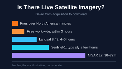
Quick Answer: Not in the sense of a live video of any place on Earth. The closest things to live are geostationary weather images, which GOES and Himawari refresh every 10 minutes for the whole disk and every 30 seconds to 2.5 minutes for small areas, at kilometre-scale detail, and fire detections, which NASA FIRMS publishes within 3 hours worldwide and within minutes over the United States and Canada. Detailed images arrive later: Landsat 8 and 9 scenes within 4–6 hours of acquisition, Sentinel-1 radar typically within a few hours, and NISAR's standard Level 2 products in 36–72 hours. Google states that its map imagery is not real time.
There is no live satellite video of most places on Earth. What exists is a set of data streams with very different delays: geostationary weather satellites refresh an image of the whole disk every 10 minutes, fire detections reach the public within minutes to 3 hours, and detailed images from Sentinel-1, Sentinel-2 and Landsat arrive hours to a day after the satellite passed. This article gives the delay for each, with the source, and explains where the delay comes from.
Two numbers decide how fresh an image can be. The first is how often a satellite passes over the place, which is covered in How Often Do Satellites Take Pictures of Earth?. The second is the latency: the time between the satellite taking the image and the image becoming available to download. This article is about the second.
Is there live satellite imagery of any place on Earth?
No. Google states plainly that its map imagery is not live: "Images aren't in real time, so you won't see live changes" (Google Earth Help). The images in map apps are mosaics collected over months or years. The nearest thing to live is weather imagery from geostationary satellites, refreshed every 10 minutes at kilometre-scale detail, which shows clouds and smoke but not buildings or vehicles.
What people usually mean by "live" is the newest image that exists. For detailed free imagery that is the last pass of Sentinel-2, Sentinel-1 or Landsat over the place, which can be days old because of the revisit time, plus a few hours of latency. For fire, the newest detections can be minutes old over North America.
What does "near real-time" mean for satellite data?
NASA's Earth science data system uses fixed names for latency. Real-time means less than 1 hour after the observation, near real-time (NRT) means 1 to 3 hours, low latency 3 to 24 hours, and expedited 1 to 4 days (NASA Earthdata: Data latency). Standard products, which use the best calibration and ancillary data, are "generally available 8 to 40 hours after an instrument observation" (NASA Earthdata: Near real-time data).
| NASA latency name | Delay after observation |
|---|---|
| Real-time | Less than 1 hour |
| Near real-time (NRT) | 1 to 3 hours |
| Low latency | 3 to 24 hours |
| Expedited | 1 to 4 days |
Source: NASA Earthdata. NASA also notes that "ultra real-time", used by FIRMS for fire detections available within about a minute, "has not been adopted as a formal latency designation".
The trade-off is accuracy. A near real-time product is processed with the orbit and calibration information available at the time; a standard product waits for better inputs. For a fire or a flood, the faster product is the useful one. For a measurement that has to be compared across years, the standard product is the one to use.
How fast do free satellite images arrive after they are taken?
Free detailed imagery typically arrives within hours. Landsat 8 and 9 scenes are available within 4–6 hours of acquisition, Sentinel-1 radar data within a few hours in practice, and NISAR's standard Level 2 products within 36–72 hours. Fire detections are the fastest free product: within 3 hours worldwide and within minutes over the United States and Canada. Each row below names the page the figure comes from.
| Data | Detail | Stated delay after acquisition | Source |
|---|---|---|---|
| GOES-R weather images (ABI) | Kilometre scale | Full disk every 10 minutes; US mainland every 5 minutes; small areas every 30–60 seconds (refresh rate, not latency) | NOAA NESDIS |
| Himawari weather images (AHI) | Kilometre scale | Full disk every 10 minutes; Japan and target areas every 2.5 minutes (refresh rate) | JMA |
| NASA FIRMS active fires (VIIRS, MODIS) | 375 m and 1 km | Within 3 hours worldwide; within 30 minutes (real-time) or within minutes (ultra real-time) over the US and Canada | FIRMS FAQ |
| Landsat 8 and 9 (Level-1) | 15–30 m | Within 4–6 hours | USGS: Landsat Collection 2 |
| Landsat 8 and 9 (Level-2, surface reflectance) | 30 m | Typically within 24 hours after the Level-1 scene is processed | USGS: Landsat Collection 2 |
| Sentinel-1 radar | About 5 m × 20 m (IW mode) | Typically under 3 hours for near real-time services; other products within 24 hours, "in practice … few hours" | ESA SentiWiki: Sentinel-1 |
| Sentinel-2 (Level-1C) | 10–60 m | "Available within 6 hours from sensing" (stated for the Collection-0 product) | Copernicus: Sentinel-2 L1C |
| NISAR L-band radar (Level 2, standard) | Mission-dependent | 36–72 hours; 6 hours for urgent response | ASF NISAR docs |
The Sentinel-2 figure is the one ESA publishes for its earlier Collection-0 Level-1C product; ESA's current mission page does not repeat a delivery time, so treat it as an order of magnitude rather than a guarantee. The geostationary rows give how often the image refreshes; NOAA and JMA do not state a download latency on these pages.
Why are fire detections the fastest satellite data?
Fire detections are small. A FIRMS record is one point per hot pixel with a few attributes, not an image of millions of pixels, so it can be processed and sent the moment a pass is received. FIRMS states that its near real-time data are available "within 3 hours of a satellite observation (on a best-effort basis)", that real-time data are available within 30 minutes of overpass, and that ultra real-time data come "within a minute of satellite overpass" for select receiving stations in the US and Canada (FIRMS FAQ).
The FAQ gives two figures for ultra real-time in different places, within 5 minutes and within a minute, so "within minutes" is the safe reading. The fast tiers depend on direct-readout stations that receive the satellite's signal as it passes overhead, which is why they cover most of the conterminous US plus southern Canada and northern Mexico, not the whole world.
VIIRS detections now come from NOAA-20 and NOAA-21. FIRMS states that production of new data from Suomi NPP ceased on 2 November 2026 (FIRMS FAQ). MODIS detections continue the record from Terra (from November 2000) and Aqua (from July 2002). How FIRMS detects fire and how to read its confidence and power values is in NASA FIRMS Explained.
Where does the delay between capture and download come from?
The delay has three parts. The satellite has to send its data to a ground station, which for a low-orbit satellite happens only when one is in view. The raw signal then has to be processed into a geolocated, calibrated product. Finally the product has to be catalogued and published for download. Each step adds minutes to hours, and the first depends on where the image was taken.
Downlink. A satellite in low Earth orbit is in contact with any one ground station for only part of each orbit. ESA notes that Sentinel-1 services needing data within 1 hour of sensing "require reception by local stations" (ESA SentiWiki), and that the timeliness of a Sentinel-1 product "depends on the geographical area covered by the product" (Copernicus: Sentinel-1 NRT-3h and Fast24h).
Processing. Raw data (Level 0) become a geolocated image (Level 1) and then a derived product such as surface reflectance or radar backscatter on a map grid (Level 2). Each level takes time. NISAR shows the size of the gap: Level 0 data in 2–10 hours, Level 1 and Level 2 in 36–72 hours under standard processing (ASF NISAR docs).
Reprocessing. The first version is not always the final one. USGS publishes Landsat 8 scenes first as Real-Time products, then reprocesses them into Tier 1 or Tier 2 after a few days once better orbit data are in (USGS: Landsat Collection 2 Level-1 data). Landsat 9 scenes go straight into the tier structure.
Can the delay be shortened in an emergency?
Yes, for some missions. NISAR has an urgent-response mode that delivers Level 2 products in about 6 hours instead of 36–72, triggered for example by an earthquake with a USGS PAGER alert of orange or red, a volcano at aviation colour code orange or red, or a manual request from USGS, NOAA or NASA (ASF NISAR docs). Sentinel-1 near real-time delivery relies on stations that receive data as the satellite passes (ESA SentiWiki).
Faster delivery does not mean a sooner pass. If the next Sentinel-1 or NISAR pass over the affected area is days away, the image will still be days away; only a satellite that can be pointed at the place on request changes that, which is the subject of When Can a Satellite Next Image This Place?
How fast do commercial satellite companies deliver images?
Commercial operators publish delivery times of one to a few hours after collection, measured on their own systems. Capella Space states that in the last 30 days "93% of Capella collects were delivered in under three hours, with 79% delivered in under two hours" (Capella Space). ICEYE defines time to availability as downlink plus processing time, with a standard SLA of 8 hours (ICEYE docs). BlackSky advertises "intelligence in as little as 60 minutes after collection" (BlackSky).
These are the companies' own figures, not independent measurements. They also count from the moment of collection, so they leave out the time it takes to order an image and for a satellite to reach the place. The cost and the trade-offs of buying imagery are covered in Free vs Commercial Satellite Imagery.
How do you check how old a satellite image is?
Read the acquisition time in the image's metadata, not the date of the web page or map. Every Sentinel, Landsat and NISAR scene carries its acquisition date and time in UTC. A map that stacks several days, or a basemap mosaic, can show areas imaged on different dates side by side, so check the date for the part of the image you are looking at.
In Off-Nadir Delta, the in-page maps on the Sentinel-1 SAR viewer and the Sentinel-2 viewer stack the last few days of passes, and the date picker labels each day. In the workspace map, every scene in the search results shows its acquisition time, and a Watch on an area can send an alert when a new Sentinel scene of that area appears in the catalogue. The alert says that an image exists, not what it shows. Off-Nadir Delta does not task satellites, so it cannot make an image arrive sooner than the public missions deliver it.
What is the most "live" free satellite view you can use today?
For a fire, the active fire map: NASA FIRMS detections arrive within hours worldwide and within minutes over North America. For weather, smoke or a large ash plume, geostationary images every 10 minutes. For a detailed look at the ground, the latest Sentinel-2 optical pass or, if clouds are in the way, the latest Sentinel-1 radar pass (Why SAR Sees Through Clouds), each usually available within hours of the satellite passing. How to find that pass is in How to Find the Most Recent Satellite Image of Any Place.
Related reading

Remote sensing specialist with 10+ years in satellite data processing and AI. Founder of Off-Nadir Lab. Ph.D. in Informatics (Yokohama National University, 2026). Master's in Earth System Science and Technology (Kyushu University). Co-author, Remote Sensing Encyclopedia. More about the author →