
Ship-to-Ship Transfer Detection with Satellite Imagery
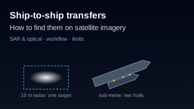
Quick Answer: A ship-to-ship (STS) transfer is cargo or fuel moved directly between two vessels at sea, either underway or with one ship moored alongside another at anchor. Most are legitimate (floating storage, blending, lightering, bunkering), but US and UK sanctions guidance names STS transfers, especially at night or in high-risk areas, as a common way to hide where oil came from. Satellite radar such as Sentinel-1 sees ships day and night through cloud, so two hulls together at an anchorage can be found on a 10 m image; it cannot name either ship or show what was transferred. Confirming a transfer takes sub-metre imagery and AIS or other records.
You can find candidate ship-to-ship (STS) transfers on satellite imagery, but you cannot prove one from a single free image. Satellite radar shows two hulls lying together at sea, at night and under cloud. At the 10 m pixel spacing of Sentinel-1 the pair usually appears as one bright target, so the job is to find where pairs occur, check them with optical imagery and, if you have it, compare them with ship-tracking (AIS) records. This article walks through that workflow and where it stops.
What is a ship-to-ship (STS) transfer?
A ship-to-ship transfer is the movement of cargo or fuel directly from one vessel to another at sea. The UK Office of Financial Sanctions Implementation defines it as "transferring cargo, goods, or materials directly from one seafaring vessel to another while both are at sea", and lists legitimate purposes: floating storage, floating blending, and "moving cargo from a vessel with a large capacity to a small capacity" (OFSI maritime guidance, section 4.2).
The operation is physically close. The P&I club Skuld notes that an STS operation "can be undertaken at sea, with either both vessels underway or one ship mooring alongside another at anchor", with primary and secondary fenders between the hulls, ideally floating pneumatic fenders to ISO 17357 (Skuld: ship to ship transfer safety). Bunkering, refuelling a ship from a bunker tanker, is a related operation that Skuld covers on the same page.
Oil transfers are regulated. Under MARPOL Annex I, the requirements apply to oil tankers of 150 gross tonnage and above: the tanker carries an approved STS Operations Plan, and a transfer in a coastal state's waters is notified to that state at least 48 hours in advance (AMSA: oil cargo transfer operations).
Why do ship-to-ship transfers matter for sanctions enforcement?
STS transfers matter because they can break the paper trail of a cargo. A 2020 advisory from the US Treasury's Office of Foreign Assets Control (OFAC), State Department and Coast Guard says STS transfers "can be conducted for legitimate purposes", but that those "especially at night or in areas determined to be high-risk for sanctions evasion" are "frequently used to evade sanctions by concealing the origin or destination" of cargo (OFAC, 14 May 2020).
OFAC's April 2025 advisory on Iranian oil is more specific. It says Iran "often uses multiple STS transfers—usually three to five—in a single shipment", that "successive STS transfers serve little commercial purpose and are a strong risk factor for sanctions evasion", and that vessels in this trade disable or alter their AIS transponders to mask "port calls and STS transfers" (OFAC, 16 April 2025). The same advisory describes the "shadow fleet" of older tankers behind this trade, which is what searches for "dark fleet tankers" usually mean. Its map of featured enforcement actions marks transfers off Singapore's Eastern Outer Port Limits, off Malaysia, in the South China Sea and near Nipa, Indonesia.
None of these documents says an STS transfer is a violation in itself. They treat it as a risk indicator to weigh with others: AIS gaps, falsified documents, flag changes and opaque ownership. A satellite image adds one more indicator; it does not settle the question.
What does an STS transfer look like on satellite imagery?
On satellite imagery an STS transfer looks like two vessels lying hull to hull, or a large tanker with a smaller vessel against its side, at sea or at an anchorage rather than at a berth. Radar shows the steel hulls as bright returns on dark water. A sub-metre optical image can show two separate decks and the size difference between them; a 10 m image cannot.
What each kind of imagery can contribute depends on its resolution and whether it needs daylight:
| Imagery | Resolution | Night and cloud | What it can show of a possible STS transfer | Source |
|---|---|---|---|---|
| Sentinel-1 C-band SAR, IW GRD | 10 m pixel spacing, about 20 × 22 m resolution | Works day and night, through cloud | A bright target or a close pair of targets at sea; usually not two separate hulls when they are moored together | SentiWiki: S1 products, SentiWiki: S1 mission |
| Sentinel-2 optical (MSI) | 10 m in blue, green, red and near-infrared | Daylight only; blocked by cloud | The vessels' shape and wakes on a clear day; whether a target is a ship or a fixed structure | SentiWiki: S2 mission |
| NISAR L-band SAR (GCOV) | Not stated here; check the product guide | Works day and night, through cloud | A second radar look, on a different wavelength from Sentinel-1 | NASA Earthdata: NISAR |
| Commercial optical (e.g. Vantor) | 30 cm collection | Daylight only; blocked by cloud | Two separate hulls side by side, their relative size and deck layout | Vantor |
| Commercial SAR (e.g. Capella) | "sub-0.25 m" per the vendor | Works day and night, through cloud | Separate hulls at night or under cloud | Capella Space |
The commercial rows are vendor statements about their own products. For why radar sees ships at all, see Ship Detection with SAR; for what 10 m pixels can and cannot resolve in general, What Can You See in 10 m Satellite Imagery?.
Can Sentinel-1 detect a ship-to-ship transfer?
Sentinel-1 can detect the vessels involved, but usually not as two separate ships. Its IW GRD product has 10 m pixel spacing and a spatial resolution of about 20 × 22 m (SentiWiki). Two hulls held apart only by fenders are closer together than that, so they merge into one bright return, longer or broader than either ship alone.
Pairs a few hundred metres apart, such as a tanker and a waiting service vessel, can show as two targets. That is still not evidence of a transfer: ships also anchor near each other in designated anchorages.
Timing is the other constraint. Each Sentinel-1 satellite repeats its orbit every 12 days, and the two-satellite constellation offers a 6-day exact repeat (SentiWiki: S1 mission). Sentinel-1A ended operations on 29 June 2026, and the mission continues on Sentinel-1C and Sentinel-1D (ESA). A transfer that takes less time than the gap between passes can start and end unseen. Sentinel-1 is better at showing where pairs keep appearing over weeks than at catching one particular transfer.
How do you find ship-to-ship transfers with satellite imagery, step by step?
Treat satellite imagery as a way to find candidate locations and dates, then narrow down. The steps below use free data first and save paid imagery for the few cases that need it. Each step can rule a candidate out; none of them on its own proves a transfer happened.
- Choose an area and a date range. Start from places where transfers are plausible: anchorages and areas just outside port limits, waters outside territorial seas, or areas named in sanctions advisories. Keep the area to the water you care about, because ship detection counts everything in it. Check when satellites will pass over it; a pass prediction gives the geometric opportunities, not a promise that the satellite will image the place.
- Search Sentinel-1 scenes over the area. Radar works at night and through cloud, which matters because OFAC singles out transfers made at night. Open the scenes in a Sentinel-1 SAR viewer and look along the anchorage for bright targets.
- Detect vessels and look for pairs. Run ship detection over the area, or scan by eye. Look for targets that are unusually large for a single ship and for pairs a few hundred metres apart. Note the date, time and position of each candidate.
- Repeat over several passes. One image is a snapshot. A pair seen at the same spot on several passes tells you more about how the place is used than one detection does. Monitoring the area so that every new Sentinel-1 acquisition is counted saves doing this by hand (continuous maritime monitoring).
- Check with optical imagery when it is clear. A cloud-free Sentinel-2 scene from a nearby date can show whether a target is a vessel or a fixed structure such as a platform or buoy. To see two hulls side by side, you need sub-metre commercial imagery bought or tasked for the date.
- Compare with AIS if you have it. Matching radar detections to ship-tracking positions shows which vessels were broadcasting and which were not. The broadcast system and what "going dark" means are covered in What Is AIS Ship Tracking?.
Consider a hypothetical scenario: a radar target at an anchorage outside a port's limits is about twice as long as the tankers around it, on two passes six days apart. A Sentinel-2 image between those dates is clouded over. That is a candidate worth a commercial image request and an AIS check, not a finding.
What can't satellite imagery tell you about an STS transfer?
Satellite imagery shows that vessels were together at a time and place. It does not show who they were, what moved between them, or why. At 10 m, imagery cannot identify a vessel: no name, flag or IMO number appears in the pixels. Several ordinary operations also look like a transfer from orbit.
- Bunkering, lightering and anchoring side by side look alike. Refuelling, moving cargo from a large tanker to smaller ones, and two ships waiting at the same anchorage all produce two hulls close together. OFSI lists moving cargo from a large vessel to a smaller one, floating storage and blending among the legitimate uses of STS transfers.
- Being alongside is not the same as transferring cargo. Hoses and pumping are not visible at 10 m, and even sub-metre imagery shows the arrangement, not the cargo.
- Detection is not intent. Sanctions advisories weigh STS transfers with AIS gaps, documents and ownership. An image of two ships together carries no information about any of these.
- Revisit gaps hide short events. With a 6-day Sentinel-1 repeat, most transfers fall between passes.
- Not every bright target is a ship. Platforms, buoys and sea clutter can return strongly; an optical check helps here.
For a broader view of how analysts reason from limited imagery, see What Is Geospatial OSINT?. Terms such as SAR and AIS are defined in the glossary.
How does Off-Nadir Delta help find ship-to-ship transfers, and what does it not do?
Off-Nadir Delta finds candidates; it does not identify ships. It detects vessels on Sentinel-1 GRD and NISAR GCOV radar scenes over an area you draw, in the app, the REST API or the Python SDK. Each detection comes back with a position, an area in square metres, its backscatter strength and a score, plus caveats on land masking and how much of the area the scene covered.
What it does not do matters for STS work:
- It does not flag pairs or transfers. There is no "two vessels alongside" output. Detections whose centres lie within roughly 300 m of each other are merged into one, so a pair moored together is reported as a single detection. Look at the image around large detections yourself.
- It leaves out vessels near the shore by default. The default detector excludes a 300 m buffer along the coastline to avoid counting quays and piers, so a transfer close to land can be missed (ship detection algorithms).
- It does not ingest AIS. A detection has no name, flag or MMSI. To find which detections were not broadcasting, match them against an AIS source you bring; the dark vessel detection tools page compares free options that do that matching.
- It does not sell commercial imagery or task satellites. It can predict when satellites pass over a place; buying the sub-metre image is up to you.
To repeat the detection on every new pass, put the area under monitoring with the ship-count metric. Sentinel-1 imagery and ship detection on it are available on the free plan, with each detection metered in tokens; NISAR is not included in the free plan (see Pricing). The general ship workflow is on the ship monitoring page, and the wider picture of satellite vessel tracking is in Satellite Maritime Vessel Tracking.
Written by Kazushi Motomura. Sources were opened on 2026-10-29. This article describes imagery analysis, not legal or sanctions-compliance advice; check the current OFAC and OFSI guidance before relying on it.

Remote sensing specialist with 10+ years in satellite data processing and AI. Founder of Off-Nadir Lab. Ph.D. in Informatics (Yokohama National University, 2026). Master's in Earth System Science and Technology (Kyushu University). Co-author, Remote Sensing Encyclopedia. More about the author →