
GEOINT vs GIS: What Is Geospatial Intelligence, Exactly?
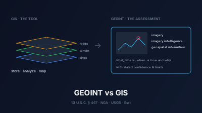
Quick Answer: GEOINT stands for geospatial intelligence. U.S. law (10 U.S.C. § 467) defines it as "the exploitation and analysis of imagery and geospatial information to describe, assess, and visually depict physical features and geographically referenced activities on or about the earth", consisting of imagery, imagery intelligence and geospatial information. GIS (geographic information system) is, in the USGS's words, "a computer system that analyzes and displays geographically referenced information". The difference: GIS is a technology for storing, analyzing and mapping location data; GEOINT is an intelligence discipline whose product is an assessment of what is happening where. GEOINT analysts use GIS, and GIS data is one of GEOINT's inputs, but running a GIS is not by itself an intelligence assessment. Much of the discipline can now be practiced on free imagery such as Copernicus Sentinel-1 and Sentinel-2.
GEOINT (geospatial intelligence) and GIS (geographic information system) are often used as if they meant the same thing. They do not. GIS is a technology: software and data for storing, analyzing and mapping anything with a location. GEOINT is an intelligence discipline: the analysis of imagery and geospatial information to judge what is physically happening at a place and time. One is a tool, the other is a kind of answer.
This article sticks to the definitions as written by the people who own them: the U.S. statute, the National Geospatial-Intelligence Agency (NGA), the U.S. Geological Survey (USGS) and Esri. If you want the open-source angle in depth, What Is Geospatial OSINT? covers that discipline; a comparison of GEOINT platforms is a separate topic and is not covered here.
What does GEOINT stand for?
GEOINT stands for geospatial intelligence. It follows the naming pattern of the other U.S. intelligence disciplines, such as IMINT (imagery intelligence), SIGINT (signals intelligence) and OSINT (open-source intelligence). The term has a legal definition in U.S. federal law, and the agency responsible for it, the National Geospatial-Intelligence Agency, describes it on its own site as "the indispensable discipline of geospatial intelligence, also known as GEOINT."
The NGA About Us page also records where the name came from: "In 2003, Congress recognized the transformative work happening across the agency by officially renaming NIMA the National Geospatial-Intelligence Agency," and in doing so "NGA cemented a new intelligence discipline – GEOINT." The statutory definition was added the same year (see below).
What is the legal definition of geospatial intelligence?
The formal definition is in Title 10 of the U.S. Code, section 467, the definitions section of the chapter that governs NGA. It reads: "The term 'geospatial intelligence' means the exploitation and analysis of imagery and geospatial information to describe, assess, and visually depict physical features and geographically referenced activities on or about the earth. Geospatial intelligence consists of imagery, imagery intelligence, and geospatial information." (10 U.S.C. § 467(5))
The second sentence is the important one for the GEOINT vs GIS question. It names three components, and the same section defines each of them:
| Component | Statutory definition (10 U.S.C. § 467) |
|---|---|
| Imagery | "a likeness or presentation of any natural or manmade feature or related object or activity and the positional data acquired at the same time", including products of "satellites, airborne platforms, unmanned aerial vehicles, or other similar means" (par. 2). It excludes "handheld or clandestine photography taken by or on behalf of human intelligence collection organizations." |
| Imagery intelligence | "the technical, geographic, and intelligence information derived through the interpretation or analysis of imagery and collateral materials" (par. 3) |
| Geospatial information | "information that identifies the geographic location and characteristics of natural or constructed features and boundaries on or about the earth", including data from "remote sensing, mapping, and surveying technologies" and "mapping, charting, geomatics data, and related products and services" (par. 4) |
The statute's notes give the history: paragraph (5), the GEOINT definition, was added by Pub. L. 108–136 in 2003, and Pub. L. 116–283 (2021) inserted "or about" so that the definition reaches activities "on or about the earth", not only on its surface. Strictly, this is a definition for that chapter of U.S. law. Other countries and organizations use the term as well, and their wording can differ.
How does NGA describe GEOINT?
NGA's own description is shorter and close to the statute: "GEOINT is the use of imagery, imagery intelligence and geospatial information to describe and depict features, activities and locations on Earth, helping users visualize what is happening at a particular time and place." The same page adds that "GEOINT goes beyond describing 'what, where and when' to exposing 'how and why.'" (NGA, About Us)
That last line is the cleanest statement of what separates intelligence from mapping. A map of where things are answers what, where and when. An intelligence assessment also commits to how and why, and says how confident it is. The National System for Geospatial Intelligence's GEOINT Basic Doctrine, Publication 1.0 (April 2018) builds on the same statutory text and its "three complementary elements". It also takes a broad view of what counts: "Any one or a combination of the three elements, and/or the data used to create them, may be considered GEOINT."
The same doctrine names GIS directly. Its glossary defines geospatial analysis as "the science of extracting meaning from geospatial data and using geographic information systems to uncover and investigate relationships and patterns in all forms of geospatial data to answer intelligence or military issues." In GEOINT doctrine, GIS is part of the analyst's method, not a rival term.
What is GIS?
A geographic information system is software and data for working with location. The USGS defines it as "a computer system that analyzes and displays geographically referenced information. It uses data that is attached to a unique location." (USGS FAQ) Its example is finding where a rare plant grows by combining slope, elevation and rainfall, then mapping every place with the same conditions.
Esri, a GIS software company, gives this formal definition on its What is GIS? page: "GIS is a technology that is used to create, manage, analyze, and map all types of data. GIS connects data to a map, integrating location data (where things are) with all types of descriptive information (what things are like there)." The same page lists what a GIS does: data management ("a foundational system of record"), mapping and visualization, spatial analysis, and communication.
Both definitions describe a system and a technology. Neither says anything about intelligence, adversaries, confidence or decisions about events. A GIS is equally at home routing delivery trucks, managing fire hydrants or planning a city park.
GEOINT vs GIS: what is the difference?
GIS is a technology for managing and analyzing location data; GEOINT is an intelligence discipline that produces an assessment about activity on Earth. GIS is defined by what the system does (store, analyze, display). GEOINT is defined by its inputs (imagery, imagery intelligence, geospatial information) and its purpose (to "describe, assess, and visually depict" features and activities). GEOINT work routinely uses GIS tools; a great deal of GIS work has nothing to do with intelligence.
| GEOINT (geospatial intelligence) | GIS (geographic information system) | |
|---|---|---|
| What it is | An intelligence discipline and its product | A technology: software, data and methods |
| Authoritative definition | 10 U.S.C. § 467(5); NGA | USGS FAQ; Esri |
| Core inputs | Imagery, imagery intelligence, geospatial information | Any data with a location reference |
| Imagery | Central (two of the three statutory components are imagery-based) | Optional; one data type among many |
| Typical output | An assessment: what is happening, where, how and why, with confidence | Maps, layers, spatial queries, a system of record |
| Typical question | "Has activity at this port changed since last month, and what does it mean?" | "Which parcels lie within 500 m of this river?" |
| Who does it | Intelligence analysts, and open-source investigators applying the same tradecraft | Planners, scientists, engineers, utilities, businesses, and GEOINT analysts too |
| Can exist without the other? | Yes in principle (an analyst reading one image) but rarely in practice | Yes, and usually does |
The two terms also sit at different levels. "GIS data" falls inside GEOINT's third component: the statute's "geospatial information" explicitly includes "mapping, charting, geomatics data, and related products and services", which is what a GIS holds. So the relationship is containment, not rivalry: GIS data is one of GEOINT's inputs, and GIS software is one of the tools used to produce it.
How do GEOINT and GIS work together in practice?
In practice a GEOINT assessment is usually built inside or alongside a GIS. The GIS supplies the base layers (borders, roads, terrain, facility locations) and the spatial operations (buffers, overlays, measurements). The imagery shows what is physically there now. The analyst's interpretation of that imagery is the imagery intelligence. The written judgment that combines all three is the GEOINT product.
Consider a hypothetical scenario: news reports say a river burst its banks near an industrial area. A GIS layer of facility locations and a terrain model show which sites sit on low ground. A Sentinel-1 radar image from after the event shows where standing water is, because radar images through cloud, which often hangs over a flood. Comparing it with a scene from before the event separates new water from the river's normal extent. The assessment then states which facilities are inside the flooded area, which are only near it, and what the 10 m imagery cannot show, such as damage to individual buildings. Every step used GIS. The doctrine would count the layers and imagery as GEOINT data too, but the part a decision-maker acts on is the last step: the judgment and its stated limits.
That last step is where most of the craft lies: deciding what the imagery can and cannot support, and saying so. For how resolution limits what an image can prove, see the four types of satellite image resolution.
What is GEOINT used for?
NGA lists the uses on its About Us page: "GEOINT support to military operations, planning, decision-making, diplomacy, intelligence analysis, strategic and tactical warning, search and discovery, and targeting." The same page says the agency's GEOINT has supported responses to "hurricanes, earthquakes and tornadoes" and humanitarian crises, and has been used against narcotics production and wildlife trafficking.
Outside government, the same discipline is applied to unclassified questions: monitoring a disaster area, checking a reported event against imagery, watching a port or strait for a change in activity, or documenting environmental change over time. NGA itself sponsors Tearline, which its home page describes as a platform featuring "unclassified geospatial intelligence from academic and non-profit contributors using open research and commercial imagery." GEOINT is not by definition classified; the statutory definition says nothing about secrecy.
Can you do GEOINT with free satellite imagery?
Yes, for questions at the scale free imagery resolves. Nothing in the statutory definition requires classified or commercial sources. Copernicus Sentinel data has free, full and open access: the European Delegated Act on Copernicus data "provides free, full and open access to users of environmental data from the Copernicus programme, including data from the Sentinel satellites" (ESA).
Two missions cover most open-source GEOINT work:
- Sentinel-2 (optical): 10 m resolution, 13 spectral bands, a 290 km swath and a 5-day revisit (ESA Sentinel-2). Good for land cover, burn scars, construction and flood extent under clear skies.
- Sentinel-1 (radar): carries "an advanced radar instrument to provide an all-weather, day-and-night supply of imagery of Earth's surface" (ESA Sentinel-1). Good for floods under cloud, ships at sea and change seen at night.
The limit is resolution. At about 10 m you can detect that a large structure, a vessel or a burn scar is present and measure its extent. You cannot identify a vehicle type or read a marking, which needs sub-metre commercial imagery. For which free sources exist and what each offers, see free satellite data sources explained and free vs commercial satellite imagery. For when to pick radar or optical, see SAR vs optical.
Do you need GIS software to do GEOINT?
No, not as a separate install. GEOINT needs the functions a GIS provides, such as placing data on a map, comparing dates and measuring areas, but those functions no longer have to live in desktop software. The trade-offs between desktop GIS and browser tools are covered in browser-based WebGIS vs desktop GIS.
Off-Nadir Delta is built to run an open-source GEOINT loop in the browser:
- The Delta Watchfloor shows geolocated world events on one map, plus events made from satellite and instrument measurements, each with the reports behind it, how precisely it is located, and whether it could be seen from orbit.
- The imagery catalog can be searched for Sentinel-1, Sentinel-2 and NISAR L-band scenes over an area and time window, and an event's imagery plan checks Sentinel-1 and Sentinel-2 against the event footprint before and after the event date.
- Satellite pass prediction estimates when a place can next be imaged, by free systematic missions and by commercial taskable satellites. It reports geometric access opportunities, not confirmed collections.
- The Delta Agent can call those same tools and explain which sensor would confirm a reported event.
What it does not do matters as much. Off-Nadir Delta serves free systematic collection; it does not resell sub-metre commercial imagery and cannot place a tasking order with a satellite operator. For what each surface does, see the geospatial intelligence (GEOINT) overview, and for working definitions of GEOINT, IMINT, OSINT and tip-and-cue, see the glossary.
Key takeaways
- GEOINT = geospatial intelligence. Legally, "the exploitation and analysis of imagery and geospatial information" about features and activities "on or about the earth" (10 U.S.C. § 467).
- GIS = geographic information system, "a computer system that analyzes and displays geographically referenced information" (USGS).
- GIS is a tool and a data system; GEOINT is a discipline and an assessment. GIS data falls inside GEOINT's "geospatial information" component.
- Open GEOINT is real but bounded. Free Sentinel imagery supports area-scale questions; identifying individual objects needs sub-metre imagery.
GEOINT as described here, and as practiced on Off-Nadir Delta, uses publicly available sources for situational awareness, research and journalism, not for targeting or the surveillance of individuals. Off-Nadir Delta is an independent project and is not affiliated with NGA, USGS, Esri, ESA or any other organization or institution.

Remote sensing specialist with 10+ years in satellite data processing and AI. Founder of Off-Nadir Lab. Ph.D. in Informatics (Yokohama National University, 2026). Master's in Earth System Science and Technology (Kyushu University). Co-author, Remote Sensing Encyclopedia. More about the author →