
What Is Off-Nadir Satellite Imagery? Viewing Angle Explained
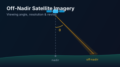
Quick Answer: Off-nadir satellite imagery is captured when the sensor points away from the vertical (nadir) direction — typically 0-45° for commercial optical satellites. Looking off-nadir degrades resolution (roughly 1/cos of the angle along-track, faster across-track) and adds geometric distortion, but it is what makes daily revisits, stereo 3D mapping, and on-demand tasking possible. Side-looking geometry is not optional for SAR: imaging radar physically cannot look straight down.
What does "off-nadir" mean in satellite imaging?
Off-nadir imagery is any satellite image captured with the sensor pointed away from nadir — the point on Earth directly beneath the satellite. The off-nadir angle (also called look angle or pointing angle) is measured between the vertical direction and the sensor's line of sight: 0° means looking straight down, and commercial optical satellites routinely task images at 30-45° off-nadir.
The distinction matters because almost every practical property of an image — resolution, geometric accuracy, shadows, revisit frequency, even whether a target can be seen at all — changes with the viewing angle. A satellite that can only look at nadir sees each point on Earth rarely; a satellite that can slew its view sideways can image a target on most passes.
The related term in the glossary: "Off-Nadir Angle — the angle between the satellite sensor's viewing direction and the vertical (nadir) direction pointing straight down to Earth."
How is off-nadir imaging different from nadir imaging?
Nadir imaging is the survey mode: fixed geometry, consistent illumination, minimal distortion, and a predictable revisit set by orbit alone. Off-nadir imaging is the tasking mode: the spacecraft rolls or pitches to point its telescope at a target that is not on its ground track, trading geometric quality for access.
Public survey missions are essentially nadir-pointing. Landsat 8 and 9 each image a fixed 185 km swath below the orbit and revisit any given scene every 16 days (8 days combined). Sentinel-2's MSI instrument has a 20.6° field of view producing a 290 km swath, giving a 5-day combined revisit at the equator — still fundamentally a "look down, map everything" design.
Commercial high-resolution satellites invert this design. A telescope with a very narrow footprint (10-15 km) would take months to revisit a target from a fixed nadir view, so agile pointing is what makes the business work: by accepting large off-nadir angles, a satellite such as WorldView-3 achieves a revisit of less than 1 day at 1 m GSD, or about 4.5 days when the tasking is restricted to under 20° off-nadir — compared with 31 cm GSD at perfect nadir.
How much resolution do you lose off-nadir?
Ground sample distance (GSD) degrades predictably with the look angle. To first order (flat-Earth approximation), the along-track GSD grows with 1/cos(θ) and the across-track GSD with roughly 1/cos²(θ), because the slant range gets longer and the pixel footprint is projected obliquely onto the ground:
| Off-nadir angle | Along-track GSD factor | Across-track GSD factor |
|---|---|---|
| 0° (nadir) | 1.00× | 1.00× |
| 20° | 1.06× | 1.13× |
| 30° | 1.15× | 1.33× |
| 45° | 1.41× | 2.00× |
This is why commercial imagery specifications always state GSD "at nadir" and quote a coarser number for a reference off-nadir angle (WorldView-3: 31 cm at nadir, 34 cm at 20° off-nadir). The image also crosses a longer atmospheric path at high angles, reducing contrast, and tall objects lean away from the sensor — building facades become visible, but rooftops no longer sit above their foundations.
Why do off-nadir images need orthorectification?
Because an oblique view displaces every elevated feature away from its true map position. A mountain summit, a building roof, or a highway viaduct imaged at 30° off-nadir can be tens of meters from its correct coordinates if the image is treated as a flat map. Orthorectification removes this relief displacement using a digital elevation model and the sensor's geometry model, producing an image with consistent map-scale everywhere.
The practical rule: the larger the off-nadir angle and the rougher the terrain, the larger the raw geolocation error — and the more essential the DEM quality becomes. The full correction chain is covered in Geometric Correction and Orthorectification.
Why does SAR always image off-nadir?
For synthetic aperture radar, side-looking geometry is not a tasking choice — it is physically required. A radar looking straight down would receive echoes from points at equal distances on the left and right of the ground track at exactly the same time, making them indistinguishable (the left-right ambiguity). SAR therefore always illuminates a swath to one side: Sentinel-1's Interferometric Wide swath mode images at incidence angles of 29.1°-46.0°.
That oblique radar geometry produces its own distortions — foreshortening, layover, and shadow in mountainous terrain — which is why SAR analysis leans on terrain-corrected products. If you are choosing between radar and optical data for a task, see SAR vs Optical: When to Use Which.
What are the advantages of off-nadir imaging?
- Revisit and tasking: agile off-nadir pointing is the difference between a 16-day survey cadence and same-day access to a breaking event. During disasters or fast-moving situations, the first usable commercial image of a site is almost always an off-nadir capture.
- Stereo 3D: two images of the same site from different angles on a single pass (in-track stereo) enable photogrammetric elevation models — the standard way commercial satellites produce DEMs.
- Facades and vertical structure: oblique views reveal building sides, under-bridge areas, and equipment that a nadir view hides — often useful in damage assessment and site analysis.
- Coverage flexibility: a constellation can concentrate collection on high-demand regions rather than waiting for orbital geometry.
The trade-offs are the mirror image: coarser GSD, more relief displacement, longer atmospheric path, and less consistent illumination between acquisitions — which is why time-series analysis (change detection, index trends) prefers consistent near-nadir survey data such as Sentinel-2, while event response prefers agile off-nadir tasking. The cost dimension of this split is covered in Free vs Commercial Satellite Imagery.
Where does the name "Off-Nadir Delta" come from?
The platform name borrows both ideas discussed here. Off-nadir stands for looking at the world from deliberately different angles rather than only straight down; delta is the change between observations that analysis is actually after. Off-Nadir Delta pairs survey data (Sentinel-1 SAR, Sentinel-2 optical, VIIRS) with event signals and change analysis — the glossary and data sources pages describe what is available.
Key takeaways
- Off-nadir angle = angle between the sensor's line of sight and the local vertical. 0° is nadir; commercial optical tasking commonly reaches 30-45°.
- Resolution degrades roughly with 1/cos(θ) along-track and 1/cos²(θ) across-track: at 30° off-nadir an image is about 15-33% coarser than at nadir.
- Off-nadir agility is what turns a 16-day survey revisit into sub-daily access — it is the foundation of commercial satellite tasking and in-track stereo 3D.
- Oblique geometry displaces elevated features, so off-nadir imagery requires orthorectification with a good DEM for mapping use.
- SAR cannot image at nadir at all: side-looking geometry (e.g., Sentinel-1 at 29.1°-46.0° incidence) is required to avoid left-right ambiguity.

Remote sensing specialist with 10+ years in satellite data processing and AI. Founder of Off-Nadir Lab. Ph.D. in Informatics (Yokohama National University, 2026). Master's in Earth System Science and Technology (Kyushu University). Co-author, Remote Sensing Encyclopedia. More about the author →