
Copernicus Emergency Management Service (CEMS) Explained: Activations, Rapid Mapping and Flood Maps
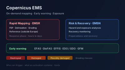
Quick Answer: The Copernicus Emergency Management Service (CEMS) is the EU's free emergency geospatial service, implemented by the European Commission's Joint Research Centre. It has three parts: on-demand mapping (Rapid Mapping for the response phase, codes EMSR; Risk and Recovery Mapping for preparedness and recovery, codes EMSN), early warning and monitoring (EFAS and GloFAS for floods, EFFIS for wildfires, and the European and Global Drought Observatories), and exposure mapping. Only authorised users — national civil protection focal points in EU and Civil Protection Mechanism countries, plus EU services — can request mapping; anyone else goes through one of them. A Rapid Mapping activation delivers Delineation, Grading and First Estimate products per area of interest (plus a pre-event Reference product outside Europe), as layered PDF maps and shapefile/GeoJSON vectors, with damage graded Destroyed, Damaged or Possibly damaged. The public activations API listed 1,068 activations on 2026-10-26. Products are free to view and download except for sensitive activations, and the service itself lists the cases where imagery cannot see the damage.
The Copernicus Emergency Management Service (CEMS) is the European Union's free service for geospatial information about disasters. It produces maps of floods, fires, earthquakes and storms on request (on-demand mapping), runs flood, wildfire and drought forecasting systems (early warning and monitoring), and estimates where people and buildings are (exposure mapping). Its emergency maps are public and downloadable unless an activation is marked sensitive.
This guide is written for analysts who want to use CEMS output: what an activation is, who can trigger one, what the files contain, and where the products stop being reliable. For the general sequence of a satellite damage-mapping response (activation, tasking, acquisition, analysis, delivery), see Rapid Damage Mapping: The Satellite Workflow from Disaster to Decision; this article does not repeat it.
What is the Copernicus Emergency Management Service?
CEMS is one of the six Copernicus services, and it is "implemented by the European Commission's Joint Research Centre". It has three components: early warning and monitoring (continuous forecasts for floods, droughts and forest fires), on-demand mapping (maps after disasters and crises, activated only by authorised users), and exposure mapping (settlement and population estimates from the Global Human Settlement Layer). The CEMS about page states that "All our products and services are free of charge."
The CEMS home page lists the parts by name, which helps when a search result uses an acronym:
| Component | Name | What it covers |
|---|---|---|
| On-demand mapping | Copernicus EMS On Demand Mapping | Rapid Mapping (response) and Risk and Recovery Mapping (preparedness, recovery) |
| Early warning — floods | EFAS (European Flood Awareness System) | River flood forecasts for Europe |
| Early warning — floods | GloFAS (Global Flood Awareness System) | River flow forecasts worldwide |
| Early warning — fire | EFFIS (European Forest Fire Information System) | Fire danger, active fires, burnt areas |
| Early warning — drought | EDO / GDO (European / Global Drought Observatory) | Drought monitoring |
| Exposure mapping | Global Human Settlement Layer | Built-up areas and population |
What is the difference between Rapid Mapping and Risk and Recovery Mapping?
Rapid Mapping serves the emergency response phase and Risk and Recovery Mapping serves everything before and after it. The CEMS mapping about page describes Rapid Mapping as providing information "within hours or days" and running 24/7/365, while the preparedness and recovery services produce pre-disaster analyses, post-disaster impact assessment and recovery monitoring. The two use different activation codes.
The code tells you which service you are looking at. In the public activations API, every one of the 873 activations with an EMSR code is in the response phase, while the 195 EMSN activations are almost all recovery (121) or preparedness (73), with a single response (counted from the activations API on 2026-10-26).
| Rapid Mapping | Risk and Recovery Mapping | |
|---|---|---|
| Activation code | EMSR | EMSN |
| Phase | Response | Preparedness and recovery |
| Timing | "hours or days", 24/7/365 | No per-product turnaround published on the portfolio page |
| Typical products | First Estimate, Delineation, Grading, Reference, Situational Reporting | Hazard and exposure analyses, flood modelling, dam-break scenarios, reference data, recovery monitoring |
The Risk and Recovery portfolio is broad: modelled flood dynamics and dam-break scenarios, wildfire hazard and burn probability, tsunami, earthquake and volcanic hazard analysis, ground deformation monitoring, evacuation planning, and human-settlement and displacement mapping for humanitarian crises. The most recent EMSN activation in the API on 2026-10-26 was EMSN238, "Dam Break Scenarios in Sardinia, Italy".
Who can trigger a Copernicus EMS activation?
Only an authorised user can request on-demand mapping. The CEMS page on who can request the service names them: National Focal Points in EU Member States and in countries participating in the EU Civil Protection Mechanism, European Commission services, the EEAS Situation Room and EU delegations. Every other public authority or organisation is an end user and has to go through the relevant authorised user. The general public cannot request an activation.
The list of authorised users (last updated 24 October 2025 on that page) is concrete: one civil protection or crisis centre per country, for example Italy's Department of Civil Protection, Germany's GMLZ and Sweden's MSB, plus Civil Protection Mechanism countries including Norway, Türkiye (AFAD), Ukraine (State Emergency Service) and the United Kingdom (COBR Unit, Cabinet Office).
The request itself is an online Service Request Form. According to How to request the service, the form asks whether the need is emergency response or preparedness/recovery, where the areas of interest are and what information is needed, and on submission it goes to the Emergency Response Coordination Centre (ERCC), which approves or rejects it.
Activations are not limited to Europe. Recent EMSR activations in the API include EMSR934 "Earthquake in Los Santos, Panama" (9 areas of interest, 12 products) and EMSR847 "Tropical Cyclone Melissa in the Caribbean" (39 areas of interest, 67 products). For events outside Europe the request still comes through an authorised user: the EMSR934 record's description opens with "Following a request from DG ECHO Panama Office". Not every record names its requester, so do not infer one from the country.
What does an EMSR activation contain?
An activation is defined by "one event and a location requested by an Authorised User" (product overview). It can have several areas of interest (AOIs), and each AOI can have several products of different types. The Rapid Mapping portfolio defines five product types, three of which can be updated over time through what CEMS calls Monitoring.
| Product | Code | What the portfolio says it is |
|---|---|---|
| First Estimate Product | FEP | "an extremely fast (yet rough) assessment of most affected locations" |
| Delineation | DEL | "an assessment of the event impact and extent" |
| Grading | GRA | "information about the damage grade, its spatial distribution and extent" |
| Reference | REF | "the only pre-event product and it is provided only for activation outside Europe" |
| Situational Reporting | SR | An online report, started "within 4 hours from activation start" |
Two practical consequences follow from that table. A Delineation map tells you where the event is (flooded area, burnt area); it is a Grading map that says how badly structures were hit. And if you need a pre-event baseline for an activation inside Europe, CEMS will not provide a Reference product, so the baseline has to come from elsewhere — for example the free Sentinel-1 and Sentinel-2 archives.
What files come with a product?
Each Rapid Mapping product is a ready-to-print map plus a geospatial dataset, and a set of base (reference) layers is provided for each AOI (what is delivered in a product). The file naming and formats page gives the formats:
- Maps: a layered geospatial PDF with transparencies removed so each layer can be switched on and off, laid out for full-colour A1 printing at 200 dpi.
- Vectors: ESRI shapefiles (.shp, .shx, .dbf, .prj) and GeoJSON, with styling rules in SLD and LYR.
Since June 2026, Rapid Mapping sends the vector data first, "on average two hours earlier", with the map and summary table following two hours later (CEMS news, 25 June 2026). If you can load GeoJSON into your own GIS, the vectors are the earliest usable output.
What is in the Situational Reporting?
The Situational Reporting is the activation's running summary. It has four sections — Activation (overview map, event summary, short timeline, production status), Exposure (population, built-up areas and critical infrastructure inside the AOIs), Emergency mapping (event statistics and 3D maps of observed impact), and Additional information (media and related services) — and it is updated until the activation closes (Situational Reporting). The exposure figures arrive first, while the first map product is still in production.
How does Copernicus EMS grade damage?
Grading products classify structures into a small set of classes tied to the European Macroseismic Scale (EMS-98). The detection methods and damage assessment page defines them:
- Destroyed — EMS-98 grades 4–5.
- Damaged — EMS-98 grades 1–3.
- Possibly damaged — used when "the confidence level of the interpretation is slightly lower", for example with poor image quality.
- Not visible damage — damage that cannot be seen from above.
The same page is explicit that the result is a proxy, "not as ground truth data". It names four detection methods: photo-interpretation (manual, for complex cases), semi-automatic extraction (supervised classification, which "works well when there are available multi-temporal images with the same sensor or resolution"), automatic extraction ("rarely used in the rapid mapping context" because pre- and post-event data rarely match), and rule-based modelling.
Read "Possibly damaged" as a statement about the interpreter's confidence, not about the building. A cluster of Possibly damaged points over a dense city usually means the image could not settle the question.
How is quality controlled?
Both the service provider and the Joint Research Centre check every product (quality control). If JRC rejects a version, a corrected version is produced within 24 hours, and only the latest version is shown on the website; the version number appears in the file names. The criteria include thematic, positional and topological accuracy, but the page does not publish numeric accuracy targets. Any accuracy figure you need has to come from the activation itself.
How do you find and download Copernicus EMS activations?
The activation list at mapping.emergency.copernicus.eu/activations is the human entry point. Each activation page has a Details & Download section for datasets and statistics, and a viewer that shows all products and AOIs together, with overlays such as GDACS cyclone tracks, Global Flood Monitoring flood extent and EFFIS active fires and burnt areas (viewing and downloading a product).
For anything repeatable, use the API. The harvesting page documents two JSON endpoints:
# All activations, paged (count / next / previous / results)
curl "https://mapping.emergency.copernicus.eu/activations/api/activations/?limit=20&offset=0"

# One activation by code
curl "https://mapping.emergency.copernicus.eu/activations/api/activations/EMSR934/"
Each record carries code, name, category, countries, centroid (WKT, longitude first), activationTime, lastUpdate, drmPhase, closed, n_aois and n_products. Both endpoints answered without credentials on 2026-10-26. The same OpenAPI schema also lists a STAC API, but it requires a token: an unauthenticated request to its collections endpoint returned 403 on the same day.
What does the activation record say about the service's history?
Paging through the full list on 2026-10-26 returned 1,068 activations, the earliest on 27 April 2012. Counting the 873 EMSR (Rapid Mapping) activations by hazard category:
| Category | EMSR activations |
|---|---|
| Wildfire | 338 |
| Flood | 304 |
| Storm | 111 |
| Earthquake | 41 |
| Other | 25 |
| Mass movement | 18 |
| Humanitarian crisis | 15 |
| Volcanic activity | 13 |
| Industrial accident | 8 |
Rapid Mapping activations per year have ranged from 21 (2012, a partial year) to 86 (2022); 2026 had 75 by 26 October. The CEMS stats page gives only the round figure "more than 1000". These counts describe what the service was asked to map, not how many disasters happened — activation depends on an authorised user asking.
What do GloFAS, EFAS and EFFIS add?
The early-warning systems answer a different question from the mapping service: not "what happened here" but "what is likely to happen, and where". They run continuously and do not need an activation.
GloFAS (Global Flood Awareness System) forecasts river flow worldwide. The forecast dataset in the CEMS Early Warning Data Store uses ECMWF's extended-range ensemble "up to 30 days", is updated daily and covers the globe except Antarctica (GloFAS forecast dataset). The historical reanalysis runs the open-source LISFLOOD model on ERA5 on a 0.05° grid from 1 January 1979 (GloFAS historical dataset).
EFAS (European Flood Awareness System) is the European counterpart at finer resolution: 1 arcminute (about 1.5 km at EFAS latitudes) in version 5.0, with lead times "between 5 and 15 days depending on the forcing numerical weather prediction model" (EFAS forecast dataset). The real-time forecasts are "only available to EFAS partners"; the public archive starts on 10 October 2018 and runs with a 30-day delay.
EFFIS (European Forest Fire Information System) covers fire danger forecasts, active fire detection and burnt-area mapping, with a network of experts from 43 countries in Europe, the Middle East and North Africa; it became a CEMS component in 2015 (EFFIS). For a global view, the same site links to the separate Global Wildfire Information System viewer.
Global Flood Monitoring (GFM) sits beside the forecasts and is observational. It processes every Sentinel-1 radar image automatically, combines "three complementary flood mapping algorithms along with reference water maps", and can deliver flood maps "within eight hours of acquisition"; it was launched in 2021 as a CEMS component (JRC publication JRC141199).
Early warning and mapping are connected. For river floods, an EFAS alert is forwarded by the ERCC to the authorised user, who can activate pre-tasking; the schedule of planned image acquisitions comes back within two hours of the alert, and early warning can let acquisitions be scheduled up to 48 hours before an event (linking with early warning systems).
What are the limits of Copernicus EMS maps?
CEMS publishes its own list of what Earth observation misses, and it is the best single checklist for reading any activation (limitations when using EO data). The general limits are resolution ("damage is too small to be visible"), timing (an image acquired outside the event window), clouds and haze, off-nadir distortion, land cover, pre-existing damage, sensor type and shadows.
The hazard-specific entries are the ones that change a reading:
- Floods (SAR): urban and forested areas mask water; smooth surfaces such as runways can look like water; wind-roughened water can look like land; shallow or slow water may not register.
- Floods (optical): water under vegetation and in dense streets is not visible; very turbid water can look like soil.
- Earthquakes (optical): collapsed buildings may not be visible from above (the "pancake effect"), and damage to side walls is not visible.
- Storms: SAR is "not suitable for identifying damages to a single structure."
- Wildfire: SAR is generally not suitable for active fires; fires under an intact canopy may not show.
Three structural limits matter for analysts as well:
- No activation, no map. On-demand mapping exists only where an authorised user asked. An event with no EMSR code may simply not have been requested.
- Sensitive activations are not public. The FAQ notes restricted activations the public cannot access, and sensitive Risk and Recovery activations that need EU Login and authorised-user status.
- A map is a snapshot of one image. The extent shown is the extent at that acquisition time. Check the image date on the map before comparing it with reports from a different day.
Consider a hypothetical scenario: a river flood is reported across several provinces, and an EMSR activation appears with a Delineation product for three AOIs. The flood extent outside those three AOIs is not "dry" — it was not mapped. The GFM layer in the viewer, or your own Sentinel-1 comparison, is the way to look beyond the AOI boundaries.
How should CEMS products be cited?
Communicating CEMS data to the public requires stating the source. The citation guidelines give the form "Copernicus Emergency Management Service On-Demand Mapping (© European Union, 2012-present_year)", and note that dissemination can be restricted in exceptional cases for security reasons or to protect third-party rights.
How does Off-Nadir Delta relate to Copernicus EMS?
Off-Nadir Delta does not ingest CEMS activations or republish EMSR products. Two parts of it borrow from CEMS directly:
- Severity scale. The damage step of Off-Nadir Delta's event severity rating uses the CEMS damage classes (Destroyed, Damaged, Possibly damaged) as its reference. In Off-Nadir Delta the class comes from what the reports say about a structure, not from an image; the scales methodology lists every external reference used.
- Flood extent for broad floods. When a flood event covers several regions and has no single point to image, Off-Nadir Delta's AI assessment of that event (a token-metered action) looks for Copernicus Global Flood Monitoring observed flood extent around it and uses that to frame the area. The source and its CC BY 4.0 attribution are listed on the data sources page.
If you want to look at the imagery behind an activation yourself, Sentinel-1 and Sentinel-2 are included in the free plan on the Off-Nadir Delta map. Load a pre-event and a post-event scene over the AOI as two layers and switch between them; Mapping Floods with SAR walks through the flood case step by step, and the SAR flood mapping guide explains what water looks like in radar.

Remote sensing specialist with 10+ years in satellite data processing and AI. Founder of Off-Nadir Lab. Ph.D. in Informatics (Yokohama National University, 2026). Master's in Earth System Science and Technology (Kyushu University). Co-author, Remote Sensing Encyclopedia. More about the author →